RhinoCity for Rhino 8 - Upgrade From Node-Locked to Floating License
|
 |
Highlights
 |
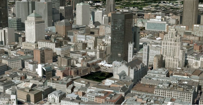
AUTOMATIC 3D MODELING
|
|
PRODUCE, EDIT, ANALYZE, TEXTURE RhinoCity™ allows you to:
|
|
 |
AUTOMATIC TEXTURING RhinoCity™ allows automatic texturing of your 3D models in just a few clicks ! Oriented images taken from vertical and/or oblique aerial shots are processed fully automatically to extract the textures necessary for the perfect rendering of 3D models. |
|
ANALYSIS AND EDITING OF 3D GEOMETRIES |
3D TILES 3D Tiles is an open specification designed for streaming heterogenous 3D geospatial content. |
Features
Import / Export
|
3D Geometry
|
3D Modeling
|
Texturing
|
GIS
|
CityGML
|
Compare
Compare RhinoTerrain and RhinoCity features
|
|
||
|
Point Cloud |
✔ |
✔ |
|
Terrain Meshes |
✔ |
✔ |
|
Ortho Imagery Mapping |
✔ |
✔ |
|
Coordinates System Reprojection |
✔ |
✔ |
|
City Modeler from Photogrammetry Vectors |
|
✔ |
|
Advanced Building Topology |
|
✔ |
|
Building Texturing from Any Aerial Picture |
|
✔ |
|
ShapeFile + Attributes |
|
✔ |
|
CityML |
|
✔ |


Original: $1,083.00
-70%$1,083.00
$324.90
Description
|
|
Highlights
|
AUTOMATIC 3D MODELING
|
|
PRODUCE, EDIT, ANALYZE, TEXTURE RhinoCity™ allows you to:
|
|
|
AUTOMATIC TEXTURING RhinoCity™ allows automatic texturing of your 3D models in just a few clicks ! Oriented images taken from vertical and/or oblique aerial shots are processed fully automatically to extract the textures necessary for the perfect rendering of 3D models. |
|
ANALYSIS AND EDITING OF 3D GEOMETRIES |
3D TILES 3D Tiles is an open specification designed for streaming heterogenous 3D geospatial content. |
Features
Import / Export
|
3D Geometry
|
3D Modeling
|
Texturing
|
GIS
|
CityGML
|
Compare
Compare RhinoTerrain and RhinoCity features
|
|
||
|
Point Cloud |
✔ |
✔ |
|
Terrain Meshes |
✔ |
✔ |
|
Ortho Imagery Mapping |
✔ |
✔ |
|
Coordinates System Reprojection |
✔ |
✔ |
|
City Modeler from Photogrammetry Vectors |
|
✔ |
|
Advanced Building Topology |
|
✔ |
|
Building Texturing from Any Aerial Picture |
|
✔ |
|
ShapeFile + Attributes |
|
✔ |
|
CityML |
|
✔ |